Fresh cyclone threat for QLD as likely tropical low ‘could start moving back towards’ mainland
A weather system with a 25 per cent chance of becoming a cyclone is expected to form off Queensland in coming days.
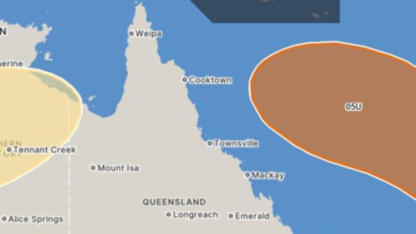
And while it’s predicted to initially move away from the east coast, there is a chance it could perform a U-turn and “start moving back towards” the Australian mainland.
“A tropical low is expected to develop in the Coral Sea this week and initially move east, away from the Queensland coast,” the Bureau of Meteorology said in an alert on Monday.
Watch the latest news and stream for free on 7plus >>
“It will likely strengthen on the weekend and could start moving back towards the southwest.
“It is expected to remain offshore for the next seven days with no direct impacts to the Queensland coast.”
The bureau rates the system a 25 per cent, or “moderate”, chance of being “tropical cyclone strength” on January 22. It’s a 15 per cent (low) chance of being a cyclone in the two days prior.
Far north Queensland has been cleaning up since the remnants of Tropical Cyclone Jasper caused significant flooding in mid-December.
Meanwhile, a tropical low off the coast of the Northern Territory could bring some areas south of Darwin up to 500mm of rain across the four days to Wednesday, with widespread totals elsewhere in the region totalling 200 to 300mm.
A severe weather warning has been issued for the Top End in the Northern Territory, including Darwin and the Tiwi Islands, with damaging wind gusts and monsoon squalls also expected.
– With AAP